Thetis Island Described in a Lifetime of Summers
- Justus Hayes

- Feb 21
- 10 min read

This post is the first in a series of blog articles that attempt to document and capture the magic of a lifetime of summers spent camping on the west coast of Thetis Island.

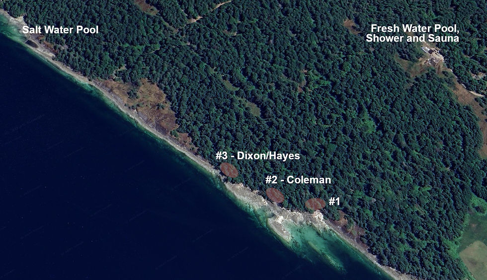
For sixty years, our family had the privilege of settling in for two weeks or so every late July/early August at Campsite #3 on private land owned and operated by local legend, Adam Hunter. The same spot every year, a cleared area under the arbutus and conifers where the forest meets a sculpted sandstone beach. My own personal experiences at Thetis started around 1971 at the age of 3, and that beach looms very large in my memory - a surreal lunar landscape dotted with tidepools containing wee crabs and bullheads.

Is there anything more entrancing to a young kid than a variety of tidepools filled with life? And will anything make a young kid more wary than a couple of falls on barnacle encrusted stone? One thing I'm coming to realize is that a huge chunk of my aesthetic when it comes to my creative work was born and shaped on this beach, under those trees, and endlessly snorkeling in those waters with a mask, fins, and an inevitable sunburn.
Before getting too nostalgic, I'd better describe the physical qualities of Thetis, its location and topography. Also some of its history, as that overlaps nicely with how the campsites came to be. Wikipedia informs us that:
"Thetis Island (population: 379)[1] is an island and unincorporated community[2] off the coast of British Columbia, Canada, lying between Vancouver Island, which is to the west across Stuart Channel, and the west from the north tip of Galiano Island, from which it is separated by Trincomali Channel.[3] With its immediate southern neighbour Penelakut Island (formerly Kuper Island), it is one of the Gulf Islands. Thetis island is 2,560 acres (10.36 km2) in size. It is approximately two miles (3.2 kilometres) wide and three miles (4.8 kilometres) long north to south."
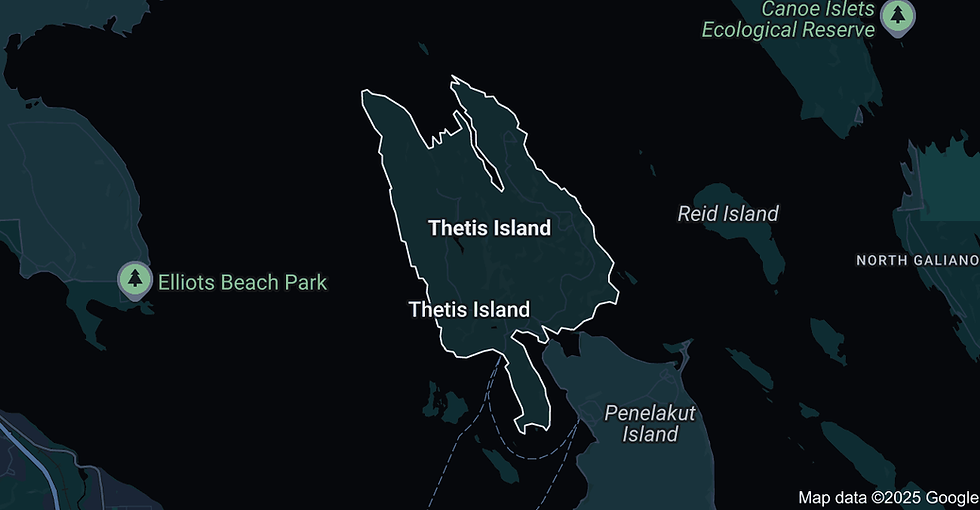
That population figure is from 2016. Nowadays the permanent, year-round population is closer to 475. The following screencaps help orient exactly where this island is located:


Thetis Island is accessed by car via a ferry from Chemainus, itself a colourful place in the literal sense. Chemainus was once a thriving little sawmill town that reinvented itself as a place known for its murals when their large sawmill closed down in the early 80s.

If I ever need evidence of the subjective plasticity of time, I need look no further than the drive from Victoria to Chemainus when I was little. In my memories, that drive constituted a monumental journey of epic proportions, an almost unendurably long ride, made only just bearable by a stop for ice cream at a place on the Malahat. It boggles my mind a little to equate the length of that drive to, nowadays, driving from Burnaby, where we live, to Chiliwack or Squamish.

The ferry from Chemainus services both Thetis and its extremely close southern neighbour, Penelakut Island, formerly known as Kuper Island, and home to the Penelakut Tribe. We shall be returning to Penelakut and its troubling past later, but we will put a pin in that for now and note that the two islands are nestled so close together that they are joined by a mud flat that has to be regularly dredged. The two islands dovetail to form one of the most protected harbours on the west coast of BC, Telegraph Harbour. The harbour is home to two marinas, Thetis Island Marina and Telegraph Harbour Marina.

Here are a couple of great resources for the ferry. Thetis Island Ferry Cam (updated every 2 minutes) and the official BC Ferries Current Conditions page for the route, also including a lineup cam.

Arriving at the ferry dock and driving off the boat on to the island was always a heightened and exciting moment. As a kid, because we were finally, finally, FINALLY there. As a teen and later adult, because all responsibilities, obligations and anxieties were off the table for the duration. Holiday mode.

I'm going to show with maps exactly where our campsite was, as well as the other campsites and other notable features on the Hunter property. I feel comfortable doing that because anyone with basic internet skills could figure it out with little difficulty. Before I do, though, I need to be clear that the property has changed hands since our time there, as will be described below, and is definitely private property. In fact, the parcel of coastline containing all the campsites sold last year, and I'm sure the new owners would not appreciate unexpected visitors.

I should probably explain a little about why I'm starting this project now, especially since it's an idea I've had lurking in the back of my brain since my twenties. Even back then, it was clear that these summer holidays would not be available forever. Adam, the patriarch, was getting old, his sons were not nearly as motivated as he was to continue the practice, and it seemed likely that, some time after Adam died, the bulk of the property would get carved up and sold. Adam did pass away in 2005, but the tradition was carried on for another fifteen years by his son, Don Hunter and Don's wife, Gwen. My last summer there was in 2011, along with Lisa, Alex (aged 5) and Rowan (aged 2). It was a fantastic time, but it became obvious quite quickly that it would not be a safe environment for Rowan once he got more mobile. That became crystal clear one afternoon when when we had a serious scare as he choked on a pine cone (for those of you who don't know, Rowan has Down Syndrome, is lightly Autistic, and remains nonverbal). My younger brother, Sean, was also there that year with his wife, Audrey, and their two girls. They continued to go for some years after that, and I will have to confer with Sean about when their last trip up there was, exactly. I lost track of the current status of the property as time went by because I knew my immediate family's time there was, unfortunately, at an end.
Then, about a month ago, I was searching YouTube for videos about Thetis out of, mostly, idle curiosity and also because the urge to write this thing had gotten a little stronger recently. I was, understandably, amazed when I ran across the following video, posted early last year, that listed for sale that piece of property containing all the campsites. Designated lot 19, it turns out, at 339 Mill Road:

Of course, I had to know if it had sold and, if so, for how much. I contacted the realtor via email, who informed me that the property had sold for $2,150,000. When I talked to Sean about it, he told me he and his family took a day trip up to Thetis last summer and met the new owners and their adult kids, who were camping there. A very pleasant family from Ontario, the parents planning to retire here on their new patch.

I have to admit, that was a very weird day for me, learning all this new information. Buying that land was never even remotely possible, and I had long ago come to terms with that intellectually. Watching that video, though, seeing those realtors walk around on land that means so much to me and extol its virtues, was a very visceral and emotional experience. It was now gone forever, really gone, without even the possibility of a return one day beyond the kind of beach-walking day trip that Sean had indulged in. It was a galvanizing experience, in as much as the desire to work on this documentation project came storming up to the surface and demanded immediate action. Within two days I had bought a new printer with a flatbed scanner and had started sorting through our multiple bins of family photos.
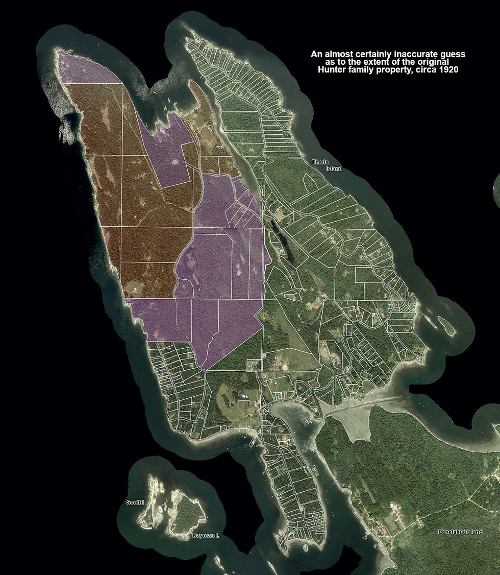
So, where exactly is this little piece of paradise on the island and what does it consist of? Let's start with some satellite images of the island. The first two are screengrabs from Google Earth, and the third is a satellite image with property lines and roads superimposed (from the excellent Islands Trust website). The fourth has been shaded red to indicate my best guess as to the extent of the Hunter property when we started camping there in the 1960s; the white arrow locates our campsite on, it turns out, within degree seconds of the 49th parallel.


I should take a moment here to recommend the Islands Trust website for information about the Gulf Islands. Here's their section devoted to Thetis Island, and here is their 52 page PDF called Community Profile that is very informative. While I'm at it, here is an active community-notes/blog website with photos, some history, and current events.
Looking at that last image above with my best guess as to the extent of the Hunter property by the 1960s, you can see that their holdings were very large and almost entirely undeveloped. I'm almost certainly wrong about the size of the property at that time, however, and it was probably larger. I've drawn the eastern border to coincide for the most part with North Cove Road (a road that the Hunter family put through, back in the day), but there are a couple of big and juicy lots just to the east of the road that were likely their property at that point. By the time our family came along, the sprawling Hunter lands were already significantly diminished from the family's original holdings. They were one of the pioneering families that developed the island in the late 1800s and early 1900s.
From the Wiki:
"Before contact, two Cowichan tribes inhabited Thetis Island, the Yekolaos[5] and the Lilmalche.[6]
Thetis was first settled by Europeans in 1874 but permanent settlement took hold in the 1890s and 1900s. One of the early families on Thetis Island was the Hunter family. In 1891 Peter & Joseph Hunter purchased lot 27 from Mr. Walls, and then a couple of years later, lot 18 from Olaf Gustafson. Descendants of Peter Hunter continue to live on the northern coast of the island."
From the Islands Trust:

"One more pioneer family that needs an introduction is the Hunter family because their work logging and building roads on Thetis created much of the island’s current infrastructure. When Adam and Margaret Hunter got married, they took up residence in the large home at North Cove. This became the centre of the successful logging company as well as a social destination. Margaret had a reputation for her baking skills and this home was a place to visit. With six boys their home was a lively place as all the teenagers on the island were always welcome at the “Big House”. The Hunter family also supported the creation of another island institution through their donation of land just west of the North Cove “Big House” for the Christian Camp, Pioneer Pacific."
Additionally, from the Chemainus Valley Courier, a little more information about those early years:
"Thetis Island was given ferry service in 1959. The new ferry was named after Ethel Hunter, a pioneer of Thetis Island. Ethel Fawcett arrived on Thetis Island in 1908 and married Peter Hunter. Peter and his brother had bought some land on Thetis in the late 1800s and proceeded to clear the land to build their home. Ethel and Peter had two children, Ena and son Adam. They were the pupils at the Island’s first school. Ethel took part in the ferry inauguration ceremonies with relish and aplomb. She was 80 years old then and lived to be 92. Many of her descendants still live on the Island."


Given all this publicly available historical information, along with my own personal recollections (spotty) of conversations over the years, I can hazard a guess as to the size and shape of the lands owned by the Hunters around the 1920s. It's certainly mistaken in many details, and I'm going to try and improve its accuracy by contacting one or more of the surviving Hunter sons, but the following image is likely in the rough ballpark:
It's at this point that I have to pump the brakes, because, from my perspective, a year has past since writing the above. I did try to contact a couple of Adam's sons to ask them about the history of the Hunter lands, but did not receive a reply to my email. I haven't given up on this avenue of research, since it would certainly be the most direct and, likely, the most fruitful, but that failure did put this project on hold for quite some time.
That impasse broke very recently as a result of my new, ongoing collaboration with ChatGPT. For about six weeks, I've been using ChatGPT to work on an audiovisual art project, called Pink Eye - I encourage you to visit my YouTube channel to hear the break-based music I'm making with the use of Suno, sometimes accompanied by videos made with Midjourney. I've posted here a few times about this project and will continue to do so in the future, so check the Feed for more information.
It occurred to me about a week ago that I could enlist the AI to help me research public records about the history of land ownership on Thetis Island generally and the Hunter properties specifically. I did so, and the results, while ongoing, have been very productive. I will cover that research and dive deeply into the island's history in the next installment of this series of blog posts. I promise it won't take a year for the next one.
Let's close out with a few screengrabs from Google Earth showing where out camp was on the coast.